Friday, December 14, 2012

Reluctantly I Headed to D.C. (And Had a Pretty Good Time!)

Last week I had to take a trip to Washington DC for work. I LOVE traveling, but traveling for work isn't nearly as fun. I wasn't really looking forward to the trip - on top of having a cold, I was going to be engaging in 'team building' with 40 strangers. Ick!

At the El Paso airport, I discovered that TSA is doing extra-special 2nd base checks... The TSA lady ran her hands down my sternum and around my ribcage, multiple times. I boarded my tiny puddle-jumper to Denver to enjoy having the whole row to myself. So I took advantage of the No Seat Belt sign and gorgeous day and took lots of photos (with my cell phone so the pics are crappy).

We flew along the Permian Reed, with El Capitan and Guadalupe Peak out my window. I waved down to my boyfriend as we passed Carlsbad. Northern New Mexico is pretty cool to see from the sky. Its all desert plains and huge mountainous patches of black rock left, remnants of 10,000 year old lava flows. (geology nerds rock!) 

To the west, the Sandias and Jimez mountains were capped with snow. My first snow of the season!


Wow! Southeastern Colorado is boring! I was hoping to see Great Sand Dunes National Park but no, just flat, brown, agricultural fields.


The front range of the Rocky Mountains is pretty amazing to see. Just imagine those poor pioneers, after thousands of boring flat miles of Kansas and Missouri, to be hit with this site. Little did they know the landscape would be rocky and mountainous all the was to the Pacific. Awesome!


Even the Denver airport has some snow-capped peaks.:-)

Inside the airport I encountered some local wildlife.... a flock of sparrows flying around the terminal eating crumbs off the empty seats. Once on the completely packed plane, I discovered more wildlife.... our pilot had a very strong, very cliche New Jersey accent. Just what I need, the Jersey Shore cast piloting my jet across the country.

At Dulles I was surprised to find some super-helpful airport workers (take notice, Houston Intercontinental bitches!). I thought they were extinct! A very nice eastern African traffic director noticed I was lost and pointed me in the right direction, even stopped traffic so that I could get across. Then a west African shuttle driver helped me find which bus I needed to get to my hotel. It was 11pm and I'd been traveling for 12 hours. My brain was fried.

The next two hours consisted on a random midnight tour of Georgetown, where all I could think about was The Exorcist, and cleaning all of my 'fancy office clothes' in the hotel sink. My shampoo exploded and the freezer bag I had packed it in was open.

This is only the 1st day and I'm already exhausted. Seriously not looking forward to this trip.

The rest of the week was a blur of meeting rooms, new faces, and Team Dimension profiles. However, we got a lot of sight-seeing done too!

The White House!


Washington Monument, cracked and broken
so nobody can go inside


The Navy Memorial Museum - where they were
practicing for a Pearl Harbor memorial event


Very cool statue at the Navy Memorial
Museum reminded me of my grandfather


Ford's Theater - the box where Lincoln
was assassinated


From the top of the Old Post Office tower -
Looking up Pennsylvania Ave towards
Capitol Hill


Christmas Tree Concert at the White House

Oh yeah, we also got free tickets to the White House Christmas Tree Celebration - it was freezing, I'm not into crowds, and I STILL had a cold - but I went nonetheless. When the Deputy Director of the National Park Service gives you free tickets to a White House event, you go.

It was a star-studded concert, with Neil Patrick Harris
hosting, and the Obamas reading
The Night Before Christmas to us all
It was an awesome evening!


Things I learned from my trip to DC?
1. City life is fun but ultimately not for me. All that walking and concrete and traffic and noise? Ugh!

If you have enough money, you can
afford your own tiny spot of
nature, on a roof

2. When standing with 8000 strangers in front of the White House, no amount of bandwidth will allow you to access Facebook to brag or text photos of Phillip Phillips to your best friend (who LOVES him). So I'll post a quick video here :-)

Yes... that's me screaming throughout the video.
(try my YouTube page if you can't get the video to play here)


3. Getting kicked out of your meeting space because the President of the United States (or POTUS) needs to talk to 150 leaders of Native American tribes is pretty cool.


4. Introducing non-city people to Tapas is both interesting and amusing


5. Room service and a bubble bath make for a damned good evening


6. The Secret Service have traffic stops down pat! They can get VP Biden from his house in Georgetown to the White House with only minimal disruption to us commuters. ps - they will wave at you if you wave at them (not the snipers, never wave at snipers)


7. Even a reluctant work trip can have some pretty awesome adventures attached.

Flying over snow-capped Rockies is gorgeous!

Tuesday, November 27, 2012

Taking My Life in My Own Hands (on the Camino Del Diablo)

Camino del Diablo translates to Road of the Devil.

Doesn't sound too appealing... unless you like to 4-wheel drive or you live along the US-Mexico border. Well, I was living in Organ Pipe Cactus National Monument in a house only 4 miles north of the border and this road , or camino, was legendary.

This road was first made famous by Spanish soldier Melchior Diaz and Padre Kino in the 1500s. These Spaniards followed the road made by prehistoric Hohokam people and historic Tohono O'odham people. It was considered the only way to cross the driest part of the southwestern desert due to large tinajas (earthen bowls filled with water) that could be found in the mountains. During the gold rush of the 1840s, many men died along this route trying to get to California. This ancient road is literally lined with the graves of adventurers passed.

Now do you understand why this road got its name? Let me tell you about the two times I crossed it and hiked into its wild mountains.

When I first decided to drive the road, I knew I needed a companion... preferably one with a gun and the ability to use it. Seriously the only time I've EVER felt this way while traveling. My friend Leo was my first choice. He's a lot of fun to hang with, great experience in the desert, a federal law enforcement officer (federal LEO, hence the name I've given him), and has a Spot personal locator beacon.

Such a good book!
Leo and I began looking into the road. We found out that we needed a free permit from the local bombing range (you know, just in case they decided to bomb the day we were driving by. no worries here!). We also started reading random books written about the area to learn about the regional history. I chose "The Devil's Highway", an aptly named book about immigrants walking across the Arizona desert and the tragedy that ensued. Basically this book taught me all I never wanted to know about dying of thirst in the desert.

Needless to say, we packed some extra water, snacks, left notes for everyone telling them where we were and when we hoped to return, gassed up, got our "don't bomb us" permit, and took off!

The road starts out just south of town as a very nice dirt road. I've seen octogenarians in sedans driving it while bird-watching. It gets a little bumpy as it travels into Organ Pipe and passes Bates Well, an old ranching homestead.

not a lot left of the ranch

Due to the water resources that undoubtedly brought the Bates Well ranchers to the area, it is also a great place for illegals crossing the desert. So, this is the first place we will see evidence of Border Patrol. These 3 metals boxes, which must feel like ovens in the 120 degree summer, are housing units for the BP and are probably mostly used during marijuana  crop season.


My second trip down CdD, I ran into these BP guys.... got stuck behind them for several miles before they pulled over and let me by. The CdD is a two-way one-lane road. Passing is tough and meeting on-coming traffic is tougher.


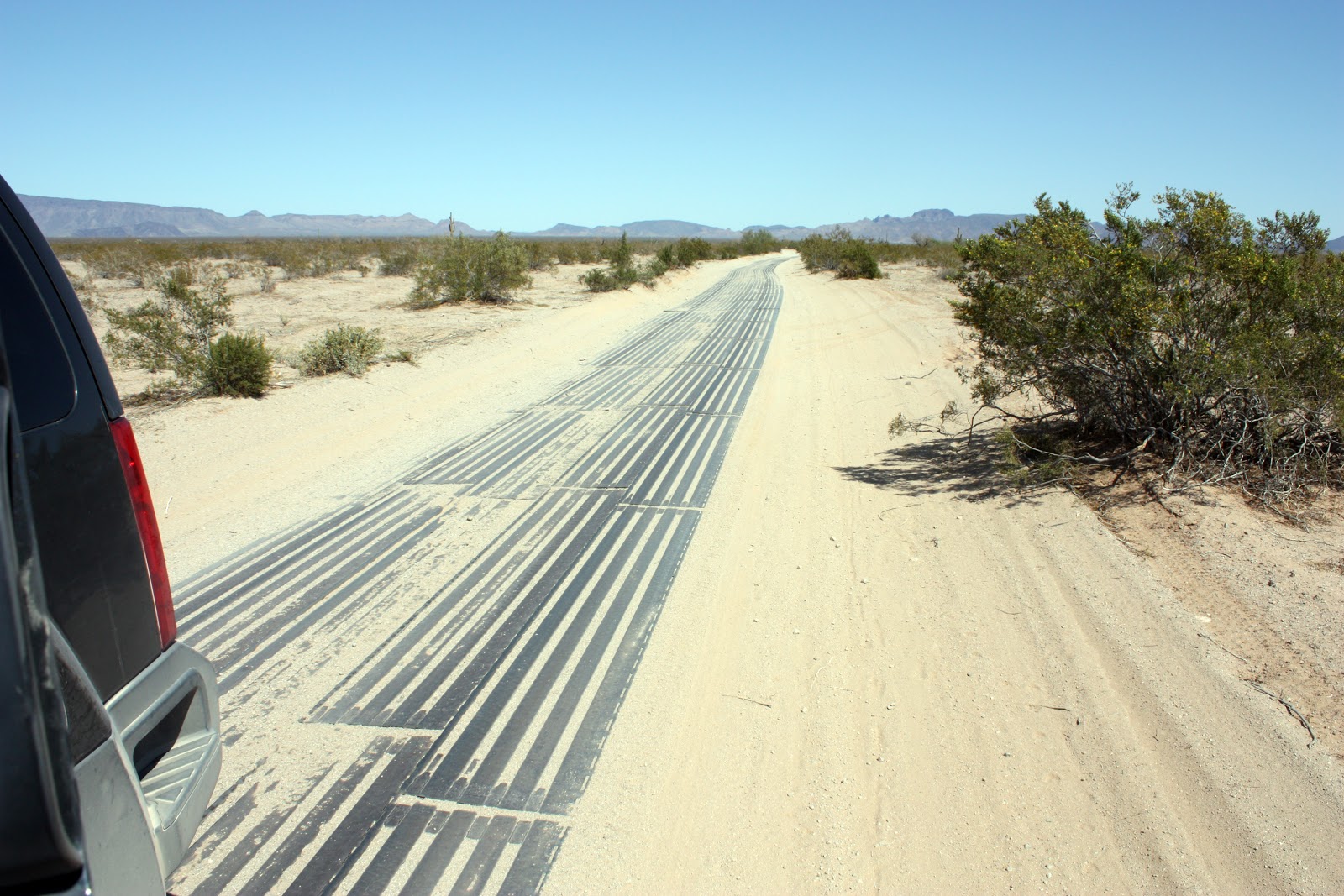
Once the road exits the park and heads west, it gets pretty sandy so someone, I'm assuming BP, put down metal runners. These are slippery and loud and interesting to drive on. They only run for a few miles.

Seriously wanted to slam on my brakes at a high speed to see how far we would skid...


A lot of the drive was spent watching for graves on the side of the road - we saw a few but didn't get photos. Not gonna lie - a lot of the drive was spent watching the south side of the road for humans hiding in the bushes or running across the desert. We never saw anyone suspicious. We did, however, see this....

the astroturf is a nice touch... we know you're
scared and dying of thirst and possibly heatstroke
or tuberculosis, but here is some
astroturf to remind you of civilization.

This is one of several beacons that save lives. Written in English, Spanish, and Tohono O'odham, instructions state that by pushing the button, help will arrive within one hour and you should stay in place. The button not only sends signal to the nearest Border Patrol outpost but it also lights up a flashing beacon for anyone to see.

There is a large BP outpost set up out there along the way. Its not at all inviting but it did ease my mind as Leo and I drove by it. We had been traveling on hard packed dirt but up ahead was a very large valley, and valleys mean one thing: Sand. Sand is not a 4-wheeler's friend. I wanted to stop and have Leo drive but he refused, saying I needed to drive to prove to myself that I could do it. (Later he admitted that he didn't want to get us stuck and then have all of his LEO co-workers find out. So there! Now they all know. :-)  )

Not only was there sand, but the road was so entrenched that I was grateful for all 10 inches of clearance my Xterra provided us. Imagine being forced, at 30mph, to choose one of several paths, all the while knowing that you'd be stuck with the path chosen no matter what because your vehicle literally wouldn't be able to get out of it. That's exactly what happened; only oh wait! Don't forget the sand - powder-fine sand was billowing up all around the car so much that I had to turn on my windshield wipers. (Yes, I have indeed used windshield wipers in one of the driest places in north america - for sand, not water.) The wipers only marginally helped but never fear, the horrid trenched road kept us on path - remember those old timey model T cars at AstroWorld that straddled an iron bar, bouncing you back onto the path every time you tried to steer away? Yeah, same theory here. So here we are, driving blind at 30 mph in a trench filled with powder-fine sand, when it dawned on me that this is a two-way road and anyone coming directly at us would be in exactly the same predicament we were in. The constant scare of a head-on collision really did wonders for my other nagging concern for traversing the Camino in the first place. Thanks!

Of course Leo and I survived the trenches... and continued onto the flats. A lot of flats...

Eventually we hit the next series of mountains (the Camino crosses through a series of Basin and Range-style mountain ranges. This is where the water is and this is what made the desert cross-able ) The next mountain pass was pretty cool. There was a  primitive campground and a few small buildings. I guess one was a house or small store or something. Whatever, it was shade! We stopped in to take a look around. Someone a while back had stashed a composition notebook in there and all Camino-crossers had signed it. As I sat there and read all the entries over the last few years, I recognized a few names and had a few laughs. I was reminded of the notebooks left in huts all along the Appalachian Trail. Those are filled with some good reading!

The road splits around a few of the mountains several times, is filled with lots of dead-ends, and lots of beckoning places. Leo and I chose to take a side-road south, for reasons I can't remember. We traveled a pretty route between two mountains that was twisty-turny, steep-walled, and had been described in a book as 'a great place for banditos to hide and hijack a vehicle'. Awesome and I definitely agree. I was very uncomfortable with the idea of parking and walking away from the car in search of petroglyphs. The last thing we needed was to lose our vehicle in the middle of desert nowhere! Once we were out of Tinajas Altas Pass, we were soon stopped by BP. (It wouldn't be the last time we took a road less traveled and were stopped by BP. More on that another time.) It was nice to see someone along that section of road because we weren't exactly sure where we were. He pointed us up a road that led through another pass and back to the main route.

The road became very wide and flat, and we ran across a military training - I don't know what branch or what you call a group of military people because I simply don't care. Here was an encampment, training and exercising along the Camino. It was pretty disconcerting to see tanks and military weapons moving around out here in the beautiful wilderness. We were approaching Yuma so I'm guessing they come out of there to strafe and train and whatnot. The road soon dumped us unceremoniously out onto the highway and back into civilization. Our 13-hour trek along the Camino had come to an end. Its so odd to think that just miles south of Interstate 8 where people are whizzing by on their way to the Pacific Ocean, there is a whole other world waiting to be explored. (and it took more than a month for all of the powder sand to disappear from my vehicle.)

On a Camino trip the following year, my friend S and I went in search of Tinajas Altas - an infamous canyon filled with water, petroglyphs, and probably illegals. Past the mind-numbing flats, the powder sands, the campground... We knew how to sniff out rock art - go into the desert and find water... not so tough!

Looking north out of Tinajas Altas Canyon
We found Tinajas Altas, climbed up into it a bit but didn't want to get stuck like so many unfortunate animals have done. We spent a few hours looking around for petroglyphs, found a few but not the main ones we were hoping to see.

S standing lower left, climbing up around the canyons
All in all, both Camino trips were packed with adventure and wilderness. I draw happiness from knowing that there are still wild and dangerous places out there in the U.S., places to still head out into the unknown.


Thursday, November 22, 2012

Happy Thanksgiving (although I confess this has historically been one of my least favorite holidays)

Today I am thankful for the long hard road that has led me to my first completely compassionate Thanksgiving Day. I am thankful for my friends and family who may not always agree or understand but are supportive nonetheless. I am thankful for a fantastic boyfriend who loves me as much for our differences as for our similarities. I am thankful for the Vegetarian Society of El Paso, a group of people who I never expected to meet and never expected to have such an impact in my life.

There are many other things in this world I'm thankful for, like sunlight soaking into my skin or the smell of the air in a pine forest or for my grandma Joy and all her undying support of me throughout my life. But, for today, I'll stick with the short list above. The rest are just for me.


The Kritzler clan of Texas, Ohio, and a bit of Canada (c. 2009)
The Hines clan of Texas and Iowa (c.2006)
What are you thankful for today? (Please don't say Black Friday Sales or I will Punch You in Your Throat!)

Thursday, November 15, 2012

Devil's Hall with the boys

This last weekend I headed out to Guadalupe Mountains National Park with M and his boys for a Veteran's Day hike. Guadalupe contains the highest peak in Texas as well as some world-renown geological specimens from the Permian Era. In the fall, people migrate there in droves to see the only fall colors around this region. Most people head to the more famous McKittrick Canyon but we were hitting M's favorite place - Devil's Hall.

Last week a local newscast aired an interview on location they did with M in Devil's Hall and since then the place has had more El Pasoan foot traffic than ever before! So I guess mass media really does still work.

I have done this hike many years ago but I barely remember it and half of hiking is the company you keep, so this trip would be fun.

The forecast was a bit dismal for my south Texan bones... windy (50mph) and cold (high of 50). I dressed as warmly as I could, brought extra stuff for the kids in case they're as wimpy as I am, and still froze my ass off. Even with the hiking, I was cold. (blood flows to muscle, leaving fatty tissue to stay cold.... read: my ass, my thighs)

We started hiking after lunch so that the weather was a bit warmer. However, we were hiking in a canyon so we also had no sun.... brrrr! Thank you weather gods for the absence of wind. The Guads are known for their incredible wind storms.
The hike started off sunny...
However, we were headed into a canyon and
would soon lose our light and solar-warmth

We did see lots of great fall color. This isn't New England fall color but when one or two trees are brilliant red and surrounded by white rock, it really stands out. Most of the time I couldn't photograph the color due to the shadowy canyon light.

Bright red big-toothed maples were everywhere
Texas Madrone berries added great color, but
taste awful!
White is a color.... There were several
yuccas blooming along the trail. They
bring in the bats and moths. Yay!
There were other kinds of color too - brilliant purple
colored all the rocks from Ringtail urine - probably
purple from eating berries

After a bit of trail hiking, in which the boys took turns looking for cougars with binoculars and spilling water on their shirts, we headed into a rocky wash to hike for a mile to Devil's Hall. This is what we like to call "kid nirvana"....

Jumbly awesome rocks to climb on!
And climb them, they did!


At one point, in the narrow rock-strewn canyon, I heard rustling in the bushes high overhead. I shushed the boys (have you ever tried to shush 10 year olds? its not an easy task) so we wouldn't scare off whatever animal was up there. Turned out to be a deer family of 4 eating an afternoon meal. They stared at us; we stared at them. Once the boys had a good look at the deer in their natural habitat, we were off for more rock climbing.

Towards the end of the hike, the trail goes up what's known as Devil's Stairs. These are fun but the odd way they tilt create a dizzying optical illusion.
One runs to the Devil's Stairs while the other surveys the path

Posing for photos for dad
After the Devil's Stairs, the canyon narrows even more. M and I walked in front of the boys, allowing them time to be alone with nature, and time for us to jump out and scare them from behind our hiding places.  :-)
Also gave us time to pose
for our own pictures
The canyon narrows down to almost a slot canyon.... if we were on the Colorado Plateau we'd call it a "slot canyon" but we aren't so we call it "Devil's Hall"!


M enjoying geology and fall colors at the
mouth of Devil's Hall
Devil's Hall is the end of the trail. I guess you could bushwhack up a few more yards but not with kids... Another day perhaps. So we turned around and headed back out. We saw the deer in the same spot as where we left them. I even found the boys' lost binoculars in the same spot they left them... All in all, a good day out in the wilderness, a good 4 miles of fall color, a good time!

Traveling Ancient Roads in New Mexico (or Our Urination Vacation) Part 3: Heading Home and Looking Back

One of the coolest things about Chaco Culture National Historic Site is that you can enter a few of the sites and walk around at your leisure. Many sites with ancient dwellings have rules that you can look but you can't touch. At Chaco, a few of the sites have become the sacrificial sites that visitors can enter and touch and learn from.
Enter if you want... unless you see this sign
So later in the afternoon, once we'd had lunch and recovered from our 6-mile morning hike, we toured Pueblo Bonito. This one is huge and you can walk through all of it! I think we counted 27 kivas - Kivas are circular underground ceremonial meeting spaces. Most of them are small, holding 10 people or so. Chaco's Great Houses boast the biggest kivas I've ever seen, big enough to hold 60+ people. Its like little league fields vs. NFL fields.

Large kiva at Chetro Ketl - those large circular holes in the
ground held ponderosa pine trunks which held the roof up.

The National Park Service has worked pretty hard to maintain these Great Houses, sometimes rebuilding parts of them for our education, and sometimes keeping them unexcavated until future archaeological techniques are perfected. However, some of the maintenance we saw on the Great Houses were pretty funny...

a rain gutter?! Those Chacoans really
were advanced!
support beams holding up an
unprecedented 3-story 1,000 year old wall

Perspective.... the ancient Chacoans were
shorter than my 5ft, 9in self but this was pretty
short!
It is possible that they kept doorways short to
keep warmer air from escaping in the cold
winter months. - M's photo

M checking out the one room that remains dark to maintain
original murals painted on the wall.

Personally, I love petroglyphs and pictographs - rock art to the layperson. More than just graffiti, rock art panels are the enduring words carved by our ancestors, by the caretakers of many of the places that are now part of the National Park Service. I am drawn to them like Homer Simpson to donuts and beer. I photograph every thing I see, catalogue what I can, and listen to what they tell me.

M's photo: petroglyphs are pecked into rock, like this swirl above
We found rock art next to almost every single Great House we came across. Most of the art is well known to visitors of the site but I still got a thrill each time I came across some. Its like reading a book - the book has been read by others but you still read it and take away your own meaning.


The canyon itself, Chaco Canyon, had 10+ Great Houses within it's 1,000 foot rock walls. Chaco Wash runs through the middle of it and this may have played a major role in why this area was chosen for such construction.
Looking down on newer smaller Great House from the top of the canyon
The canyon served as a crossroads for travelers from the four far-flung corners of the world. To the southwest there were openings heading to Monument Valley, to the northeast the great Chaco Road headed towards the ponderosa-covered mountains of northern New Mexico and Colorado.

M's photo - the famous Fajada Butte stands
at the entrance to Chaco Canyon, welcoming travelers
for the last 1,000 years.

The canyon still serves as a crossroads of culture. People from all over the world, for all types of reasons, come to Chaco. Some are searching for answers to one of North America's mysteries (where did the Ancestral Puebloans go?), some come for a love of the southwest, and some simply come because they want to check off Chaco on their National Parks Passport book. Whatever the reason, we all leave with the same thing: more questions than answers. Isn't that what travel is really all about?

Never Stop Exploring